 |
|
|
|
Home | About 'The Flat' | News | Diary | Attractions | Heritage Trail | Tourist Info | Location | Links | Community Association | Gallery | Contact Us |
||

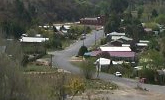
The main road to Captains Flat
|
Kilometres from Captains Flat |
Description of site of interest |
Kilometres from Kings Highway Turn-Off |
|
0 |
War Memorial - corner of Foxlow St. and the Captains Flat Road. Erected in the 1950s. There are no names listed on the memorial. A service is held each Anzac Day. |
40.5 |
|
0.05 L/H |
Wilkins Park George Osborne gave the park then known as Foxlow Park, to the people of the town. It was renamed Molonglo Park and is now known as Wilkins Memorial Park. Named after Herbert Wilkins a former assistant manager of the Lake George Mine. Wilkins was a philanthropist in the town and cared for the village people. The park contains the Winchester Oval named after a former Assistant Commissioner of the Australian Federal Police, Colin Winchester. |
40.4 R/H |
|
0.1 L/H |
Davis Creek on the west side of the town is named after the previous owners of the property, drains the hill which is topped by Bennison Trigonometrical Station. Surveyor Wood established the station on 19 July 1887. Bennison may be named after F. Bennison who operated a butcher’s in the early 1880s in Captains Flat or W.J. Bennison of Jingera who had a forage contract in 1864; a large business in Braidwood and was a JP; or Mr Bennison whose store at Foxlow was robbed by three masked men in 1865. |
40.3 R/H |
|
0.3 L/H
|
Quarry and sewage treatment plant. Rock from the quarry was used in the 1974 reclamation project of the Lake George Mine. Town sewage treatment plant. |
40.2 R/H
|
|
0.4 L/H |
Molonglo River. The River source is 12k from Captains Flat in the Gourock Range. |
40.0 L/H |
|
0.5 L/H |
Northern waste dump Faces on the tailings hill stood 40 metres high. During reclamation in 1974, the hills were levelled off and covered with layers of clay, rock, soil and vegetation. The $2.5 million project took two years to complete. |
40.0 R/H |
|
0.6 L/H |
Cutting showing steel drill bit left in the rock probably left from making the road. The dark rock is metalliferous and quartz veins are also visible. |
39.9 R/H |
|
0.7 R/H |
Dwyers Camp Settlement was the nearest camp to the railway station where men working in the mine established humpies on the flat area on the riverbank. In 1952 the Lands Department opposed expansion of the camp but proposed to legalise existing occupations. |
39.8 L/H |
|
0.85 L/H |
Track leading up hill along the fence used to go to houses. |
39.7 R/H |
|
1.2 L/H |
Copper Creek. There was a suburb called Copper Creek on the creek. |
39.6 R/H |
|
1.2 L/H |
Miners Road leads to the Lookout and Mine Entrance. The by-pass was built to avoid congestion at he mine in 1939. Note stationmaster’s house, gantry crane, weighbridge and railway goods shed. |
39.6 R/H |
|
1.3 R/H |
Alan Gallagher /Blinksell’s store with Mobil petrol pump and houses on the corner opposite the railway station. On the river flat below them were two tennis courts. |
39.5 L/H |
|
1.4 L/H |
Captains Flat Railway Station. Remodelled as a private residence in 1974. |
39.5 R/H |
|
1.6 R/H |
Old road view. The old road followed a different route around the hills to the town. It can be seen from various points on the new road. |
38.9 L/H |
|
1.9 L/H |
Beverly Hills Road. |
38.2 R/H |
|
2.2 R/H |
Jermyn Street was the limits of housing. The name was used between 1955 and 1986 for the circular street opposite the railway station leading to Newman Trig Station on Waltmans Hill. The Jermyn family was prominent in the Captains Flat and Braidwood area from the late 19th century. The family is represented in the Cemetery |
L/H |
|
3.4 L/H |
Captain’s Flat Hardwood Supplies. |
37.0 R/H |
|
3.6 R/H |
Site of Silver Hills homestead; also the private slaughtering yard. Large and small gates. Some traces of old buildings remain |
37.0 L/H |
|
3.7 L/H |
Site of John Harrison’s Yorkdale. Harrison took up land in the Captains Flat area in the 1860s. During the 1882 gold rush he converted his homestead into a boarding house hoping to lure customers from the roadway that ran past his door. Unfortunately, he died after one month in business. His wife was asked to take on Postmistress duties in 1883 but she declined the offer. In 1886, the commencement of a road from Harrison’s farm to Captains Flat “relieved local distress”. In 1888 part of the road from Foxlow to the village of Bullongong (Captains Flat) from the south boundary of John Harrison’s 60 acres to the south boundary of J. Hosking’s (latterly George Osborne’s) 79 ½ acres was resumed in lieu of the new road re-alignment. |
36.9 R/H |
|
|
Tumbledown Bob is a hill between Captains Flat and Foxlow according to the Captains Flat map of 1887 which states “Foxlow Street to Foxlow via Tumbledown Bob”. In 1863 John Reilly a resident of Bungendore while driving his heavily laden team up Tumbledown Bob Hill had a very narrow escape from the duffers. In 1863 Mr Abraham Levy of Queanbeyan exhibited a specimen of gold obtained from a boy claiming to have found it “on Tumbledown Bob between Molonglo and the Jingera”. In 1881 a gold reef was discovered and in 1882 a copper reef and a new gold bearing reef was discovered on the hill in July 1886. |
|
|
5.2 L/H |
Site of an early medical practitioner’s residence —The Doctor’s Paddock. Now known as Stony Pinch. Fruit trees are still there. |
35.4 R/H |
|
5.5 R/H |
Koomooloo Pastoral Company. Previously owned by J.K. Bain Managed by Richard Noble. Bain purchased the land from Darcy Strudwicke in 1969. Previously part of Silver Hills in the late 1890s and early 1900s. |
35.1 L/H |
|
7.8 R/H |
Silver Hills School marked by large pine tree standing on its own. |
33.6 L/H |
|
|
Creek. |
31.4 |
|
5.0 L/H |
Sinclair Road points to Sinclair Hill on the opposite side of the Captains Flat Road. The hills are part of Yanununbeyan National Park, Yanununbeyan Nature Reserve and Yanununbeyan State Conservation Area. The national park (3,500 hectares) and nature reserve (40 hectares) were gazetted in 2001, and the state conservation area (4,135 hectares) was gazetted in 2003. The name Yanununbeyan is taken from the local parish name. It is of Aboriginal origin, but its meaning is not known. Threatened species recorded in or near the park include the Speckled Warbler Pyrrholaemus sagittatus, Diamond Firetail Stagonopleura guttata, Powerful Owl Ninox strenua, Koala Phascolarctos cinereus, A large population of a subspecies of Argyle Apple Eucalyptus cinerea ssp. Triplex occurs in the dry forests of Yanununbeyan State Conservation Area. |
30.6 R/H |
|
A rare shrub in NSW; Pomaderris phylicifolia var. phylicifolia occurs scattered through eucalypt forests on Harrisons Peak. The key cultural heritage values include recorded Aboriginal sites and Foxlow Flat, where there are the ruins of a shepherd’s hut and other signs of the European grazing such as old fences and yards. |
||
|
|
Bungendore – Captains Flat Railway line close to the road. The line closed on 1 September 1968. A year after the official closure, it was re-opened to run the special train for the making of Ned Kelly by Ajax Films. Rock star, Mick Jagger, played Ned Kelly. |
29.8 L/H |
|
12.2 R/H |
Road to Hoskinstown, previously known as Black Heath (1862), Molonglo (1892) then as Hosking Town. The town received its name from John Hosking (1806-1882) of Foxlow Station. Hosking became Sydney’s first elected Mayor in 1842. John Hosking, a partner in Hughes & Hosking with John Terry Hughes, the largest merchants in Sydney entered into an agreement with Archibald Mosman to convey to them all his real estate in return for an annuity of £2,000 per annum for life, and the large cash sum of £13,750. This agreement was finalised and the annuity was paid for several years. Unfortunately, due to the acute depression of the early 1840s, both Archibald Mosman and the firm of Hughes & Hosking became insolvent in 1843 and Hosking withdrew from office. In 1871 Black Heath was the scene of a small gold rush. |
28.9 L/H |
|
R/H |
Communications tower |
28.6 L/H |
|
12.2 R/H |
De Salis Bridge over the Molonglo River on the Hoskinstown Road was opened on the Queen’s Birthday weekend, 1875 by Dr Morton to link Bungendore and Captains Flat. In 1889 agricultural scientist William Farrer married Nina de Salis, daughter of Leopold Fane De Salis & his wife Charlotte McDonald, the owner of Lambrigg station. The Rev. Pierce Galliard Smith (1826-1908), the third Rector of St John the Baptist Church in Reid and his wife Emily, came to Canberra in 1855. Rev. Smith's third daughter, Mary St. Lawrence married George Arthur Charles Fane De Salis, brother of Nina, and they lived at Cuppacumbalong. Their family comprised Charlotte, Emily, Mary, Nina and an adopted daughter Olive. They are all buried in the Church of England Cemetery, Michelago. In 1897 there were two coach runs daily between Bungendore and Captains Flat through Hoskingtown. |
28.0 L/H |
|
12.9 R/H |
Foxlow Station. Named after John Hosking’s wife, Martha Foxlowe. The Australiana fund acquired a pair of China export porcelain punch bowls with the entwined monogram of John and Martha Hosking on the inside base. John Hosking and Martha Foxlowe were married in 1829 and these punch bowls may well have been commissioned to celebrate their nuptials or perhaps received as a wedding present. Hosking purchased the land some time after 1839. The large stone building close to the road is the second residence. In 1865 three masked men robbed Mr Bennison’s store at Foxlow. Hosking sold Foxlow to Thomas Rutledge of Carwoola in 1868. Two years later Rutledge sold it to George Osborne of Currandooley. In 1871 a small gold rush occurred near Blackheath (Hoskinstown) and Mr J.W. Wright sank a shaft near the homestead.. The stables at the back of the property were once used as police barracks. |
27.2 L/H |
|
L/H |
Memorial plaque to Donna Maree Norris who was killed in a car accident at the site, in the copse of poplars by the Foxlow Shearing Shed gate opposite no. 2751. |
27.6 R/H |
|
13.4 R/H |
Mine waste pollution from the Captains Flat mines swept onto pasture land when the Molonglo River flooded in 1939 and 1942. 1000 acres were destroyed. After a court case, the mining company spread lime on the damaged areas, but the land has never completely recovered. |
27.2 L/H |
|
18.7 L/H |
View of Harrisons Peak, also known as The Pinnacle, and of Mount Foxlow. The only hill on the plain that the road goes over is Grose Meadow Hill. The ridge behind it is Rutledge Ridge and the main peak Rutledge Sugarloaf. |
19.9 R/H |
|
20.0 L/H |
Molonglo Station The first authorised settler to reside on a large holding in the district was Owen Bowen (1778-1840), a convict who had arrived in the Colony on 2nd July 1811, having sailed from Falmouth aboard the ship Providence. Bowen was freed from servitude at the age of 46 and secured a ticket of occupation for one hundred acres at Marlow Plains (Molonglo) in June 1824. Three years later he applied, unsuccessfully, for another grant at Carrowillah, which was located three miles from his holdings and eighteen miles from Lake George. In the 1828 NSW Census Owen Bowen’s Molonglo was listed as having 500 acres (300 acres cleared land and 10 acres cultivated), with 17 horses and 827 cattle and employed a brother and sister, Simon and Elizabeth Boulaway. Over the years Bowen enhanced his holdings and at the time of his death in 1840 the property was valued at 7,000 pounds. William, Owen’s son, remained on the station and bred thoroughbreds. William Bowen sold Molonglo to Thomas Rutledge in 1865 and the property became part of Carwoola. |
19.4 R/H |
|
21.1 R/H |
St. Thomas the Apostle Church and Churchyard. Built between 1872 and 1874 on land given by Thomas Rutledge near his homestead of Carwoola. Canon Alberto D. Soares, incumbent of Christ Church Queanbeyan from 1857-1877, designed the church. The stained glass windows are in memory of George, Sophie and Darcy Osborne of Foxlow and the organ is in memory of James Maslin, who was killed in World War I. James Maslin’s father, J.F. Maslin, purchased Carwoola from the Rutledge family in 1907. |
19.2 L/H |
|
L/H |
Woolcara Lane follows the Primrose Valley Creek. Leads to the eastern side of the Queanbeyan River and Queanbeyan Flats now known as The Springs and to Murdering Shed. Captain Henry Colden Antill (1799 – 1852) was one of the early landholders. He arrived in New South Wales in 1809 as Aide-de-camp to Governor Macquarie and remained on the staff until 1822. He was a magistrate. In 1833 he bought at auction 640 acres in Primrose Valley. He named it The Station and in 1848 produced salt, butter, ham, bacon and wool. Henry Colden Antill jnr, fourth child and second son, was an associate of the Jingera Mob. With Andrew Hartigan Tyrie and Jonathon Bowman, he was charged with horse stealing in December 1862. In 1863 Antill jnr and William Beaumont were charged with stealing three mares, the property of William Bowen. In a trial a month later Antill jnr and James Brown received sentences of 15 years hard labour on the roads. While in Darlinghurst Gaol, Antill wrote to the Governor telling of the habits, friends, camps etc of the Jingera bushrangers. On 27 April 1867 the Clark brothers were captured where Antill said they would. Antill jnr was exiled on petition. The estate of 7500 acres remained in the Antill family until 1862 when it was sold to Thomas Rutledge and absorbed into Carwoola. Original homestead no longer standing. |
18.6 R/H |
|
22.1 L/H |
Old Carwoola School and residence. A convict-built boys’ and girls’ toilet is visible on the left-hand side. |
18.3 R/H |
|
23.1 R/H |
Carwoola Station. 2560 acres granted to Henry Gilbert Smith in 1828. Sold to William Rutledge in 1836. His brother Thomas managed the property and eventually bought it and by 1870 also owned neighbouring properties of Janefield, Gidleigh and Foxlow. His son William Forster Rutledge (1850-1912) and grandson Lt. Col. Thomas Lloyd Forster Rutledge MLA (1889-1958) were also prominent in the Molonglo. The homestead is believed to have been built by Thomas prior to his marriage to Martha Forster in 1849. Note slab stables close to the road and a rubble-stone barn with walls half a metre thick. After Thomas Rutledge’s death in 1904 the property, which at its peak was 55,000 acres, was divided and sold off. |
17.1 L/H |
|
23.7 L/H |
Carwoola shearing shed. Stone building behind it is believed to be the first house on the property. |
17.0 R/H |
|
27 |
Molonglo River Plain. The river has been known to stretch one mile wide in flood. |
13.6 |
|
R/H |
Little Whiskers Road |
13.0 L/H |
|
R/H |
Briars-Sharrow Road named after two properties on the road, also known as the Eleven Mile Turnoff. William Balcombe (1779-1829) had settled at St Helena in 1804 as a merchant and superintendent of public sales for the East India Co. When Napoleon was exiled to the island Balcombe became purveyor to his establishment. Before Napoleon moved to Longwood in November 1815 he lived in a pavilion on Balcombe's estate, The Briars, and became attached to the family. The friendly association ended abruptly in March 1818 when Balcombe was dismissed from the island on suspicion of being too friendly. Although never charged with any offence, Balcombe was not allowed to return to St Helena. He remained in England until 1823 when he was appointed colonial treasurer of New South Wales. With his family he arrived in the Hibernia at Sydney in April 1824. On 5th August 1824, Governor Brisbane offered Balcombe a grant of 2,000 acres at Menanglo [sic] or Marley Plains about eighteen miles south of Lake George. By 1827 a stockyard and dairy had been erected, plus servants’ huts and various other buildings, with twelve acres under cultivation. William Balcombe also called this property The Briars and built a slab home just below where the present stone cottages stand today. It is believed that William was responsible for introducing two plants to Australia, the Sweet Briar and the Weeping Willow. The willow (Salix Babylonica) grew nearby Napoleon’s grave on St Helena and Balcombe is reported to have taken cuttings from these trees. |
13.4 L/H |
|
The Briars was sold to Thomas Shanahan in the 1840's when Balcombe’s sons moved to Victoria. Shanahan had previously been the licensee of the Union Inn, which was opened in 1838 at Keefe’s plains, Michelago. When he took up residence at The Briars Thomas Shanahan rebuilt the slab house further up the hill because of the flooding of the Molonglo River. The remains of that second dwelling still exist. Two later stone buildings stand to the north of this site, one built by Thomas Shanahan Jnr and the other by his son Sydney James in later years. The Shanahan private cemetery dating back to 1853 and containing eight persons is within several metres of the second slab house. There is a mine north west of the homestead, side of hill, and other stone arrangements connected to mining. |
||
|
Plains Road links the Briars Sharrow Road and the Bungendore Hoskinstown Road. Plains Road is the access road to the Molonglo Observatory Synthesis Telescope part of the Mills Cross Radio Telescope operated by the University of Sydney, which can be seen on the plain. In1834 the explorer Edward John Eyre was granted 1260 acres in this area, which he called Woodlands, which became absorbed into Carwoola in 1837. It is located on the Hoskinstown-Captains Flat Road. |
||
|
L/H |
Widgewa Road has the Tengoku Dojo, a 36 mat purpose built Akido dojo. The ACT Region Aikido group helped in the demolition of a local sports facility and in rearranging it to form a coil sprung floating floor. |
12.8 R/H |
|
27.8 L/H |
Pot holes on hill from gold fossicking days. |
12.0R/H |
|
|
Whiskers Creek |
11.8 |
|
|
Whiskers Hill Gold bearing area – also Molonglo River noted for fishing which was destroyed by the mine overflow. |
11.1 |
|
L/H |
Douglas Close Douglas Close was named after the Douglas family who farmed the area, and the road was constructed in the subdivision of the Douglas' land in 1981. Andrew Douglas was a Councillor with Yarrowlumla Shire Council. The Tibetan Buddhist Society of Canberra has its Virupa Retreat Centre there. |
10.8 R/H |
|
R/H |
Molonglo River Drive leads to a subdivision overlooking the Molonglo River. |
9.3 L/H |
|
L/H |
Radcliffe possibly named after a family who lived in the area. In 1864 Margaret Ratcliff, wife of a shepherd employed by Mr Rutledge was raped on her way from a place called Cockatoo Station near Foxlow, where she had visited a relative and the store at Carwoola. An aboriginal was sentenced to death for the attack. In 1928 J.F. Maslin auctioned Carwoola. William George Hyles purchased Lot 2 (Radcliffe) which was 2000 acres plus 1000 acres known as Stony Creek (Swans) section. William’s daughter, Mona Ruth Hyles, in 1945 married Bruce Douglas, whose father had been the manager of Carwoola up until the auction. William Hyles passed the 3,000acre Radcliffe property on to his daughter and it remained in the family until 1970. In 1970 Radcliffe was sold to the Acona Pastoral Company, who later sold it to Tony Yiep who developed Radcliffe Estate. The original Radcliffe house is sited on Lot 18 in Radcliffe Circuit. The shearing shed on Lot 19 is also one of the original Radcliffe buildings. There are the remains of even earlier dwellings and other minor structures and yards located throughout the estate. The Radcliffe Community Park is named Bowen Park. |
R/H |
|
L/H |
Kearns Parade Named by landowner when subdividing. William Kearns was involved in the discovery in 1822 of the Molonglo Plains and the Queanbeyan River and of Batemans Bay. |
7.5 R/H |
|
R/H |
Stony Creek Place The street was named for its proximity to Stony Creek and its location on the hill historically known as Stony Creek Hill. In the Stony Creek area were two school sites and a small community of the Taylor, Swan and Dunlop families. Aaron Taylor’s son Harry was Mayor of Queanbeyan, 1940-1950. |
6.6 L/H |
|
32.0 L/H |
Old road to Captains Flat running parallel to current road |
6.0 R/H |
|
|
Mooncoin was the site in of the City to Soil test project conducted by NSW Department of Environment & Conservation commencing in March 2003 where green waste was collected in Queanbeyan and taken to Mooncoin for the vines to investigate the effects on soil properties, yield and moisture retention of organic compost. |
5.5 R/H |
|
35.5 L/H |
Palerang / Queanbeyan local government areas boundary |
5.1 R/H |
|
L/H |
Clydesdale Road leads to Wanna Wanna Nature Reserve, the entrance to which is on Pony Close. The nature reserve was gazetted as part of the Southern Regional Forest Agreement in 2001, and is 33 hectares in size. Prior to 1891 two mining leases were issued for parts of the reserve. In the early 1900s these leases were utilised by the Carwoola Copper Prospect Mine. One mineshaft, two pits and mullock heaps have been recorded. Locals have also used the reserve as a source of firewood. . The reserve’s name was selected in recognition of its proximity to the once extensive Wanna Wanna property. |
4.9 R/H |
|
R/H |
Stony Creek Nature Reserve. The reserve, comprising 80 hectares, was gazetted as part of the Southern Regional Forest Agreement in early 2001, and contains a representative sample of grassy box woodland. The location of the reserve, close to Stony Creek and the Molonglo River, and its grassy understorey, contributed to the gazettal of this and adjoining land as a Water and Camping Reserve in 1878. This community is part of the broader white box - yellow box - Blakely’s red gum woodland, listed as an endangered ecological community under the Threatened Species Conservation Act, 1995. It has descriptive signage by the entrance. |
4.9L/H |
|
R/H |
Glenlee Place Named by landowner when subdividing, not known why the name was chosen. |
4.8 L/H |
|
R/H |
Surveyor’s mark low on gum tree on road verge possibly from 1936 plan to widen the road. During planning of sealing the road in 1962 an alternate deviation was from Burbong to Stoney Creek, instead reconstruction occurred on the old route “between the seven mile and the junction with the coach road”. |
3.8 L/H |
|
R/H |
Powell Drive Named by landowner when subdividing, not known why the name was chosen. In 1846 a Powell family lived at Taralla and a Powell family lived at Wanna Wanna. |
3.2 L/H |
|
R/H |
Povey Place Named by landowner when subdividing, not known why the name was chosen. The Povey family was centred at Michelago and the pioneer William Povey born 1811 died 1881 is buried in the Church of England section of the Michelago Cemetery along with members of his family. |
2.5 L/H |
|
R/H |
Cuumbeun Nature Reserve 709 hectares. The name was selected in consultation with the Ngunnawal Local Aboriginal Land Council and is possibly the name from which Queanbeyan was derived. It includes Scabbing Flat Creek that flows into the Molonglo. Includes the threatened hoary sunray Leucochrysum albicans subsp. Albicans var. tricolor. Also a number of threatened bird species inhabit the box woodland including one koala. |
2.2 L/H |
|
L/H |
Wanna Wanna Drive. Leads to Wanna Wanna. Samuel Taylor selected Wanna Wanna in 1859 and his slab hut is still standing. The present garden was founded by Florence Powell (nee Finch) in the early 1920s. The film star Peter Finch (Frederick George Peter Ingle Finch (1916-1977)), spent some of his school holidays there and came back in 1956 to jackaroo for a month preparing for his role in the film The Shiralee (1957). The gardens at Wanna Wanna Cottage have participated in the Open Garden Scheme. |
R/H |
|
38.8 R/H |
Mason Brothers Brickworks. Mason was a builder who arrived in the district in 1924. The works operated in 1926/27 during the erection of the Hotel Queanbeyan and his residence Carinya in Stornaway Road, Queanbeyan. The owners hoped to provide bricks for construction in Canberra but their product failed to meet required specifications. Old clay pit and water hole visible. In 1926 Mr W.H. Mason advertised that the price of bricks from his new brickworks at Captains Flat was £5 per thousand at the kiln. |
1.8 L/H |